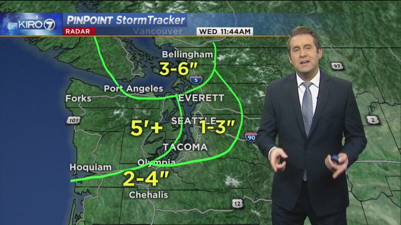
Thursday is now likely to start dry and breezy, but by noon or later in the afternoon, the data points to a northward-moving, widespread area of snow falling to at or very near sea level.
As KIRO 7 News meteorologists track snow on Thursday, here are five things to know about the forecast.
1. A Winter Storm Advisory will be in effect
Winter Weather Advisory starting at 4 p.m. Thursday to 8 a.m. Friday for all of the lowlands from south to north with the exception of Whatcom County where snow will hang on into Friday morning so their Winter Weather Advisory expires at Noon Friday.
WIND ADVISORY tonight near Cascades
— Morgan Palmer (@MorganKIRO7) December 7, 2016
WINTER WEATHER ADVISORY lowlands Thu PM-Fri
WINTER STORM WARNING Hood Canal Thu PM-Fri #wawx #wasnow pic.twitter.com/HcJ7y26iNW
The Winter Weather Advisory is for an average of 1-3 inches of snow Thursday evening and Thursday night, turning over to warmer rain by daybreak Friday except in Whatcom County where it will take longer.
Winter Storm Warning for Hood Canal region from 4 p.m. Thursday to 8 a.m. Friday for 3-6 inches of snow as the snow will not change to rain as quickly up against the Olympic Mountains.
2. Snow could begin mid-afternoon for some areas
Right now, it appears snow should begin in the early to mid-afternoon south of Olympia, possibly a little earlier, then moving north to Olympia and Tacoma closer to the mid-afternoon.
Snow will be spreading from south to north with approximate arrival times of the snow band moving up I-5:
- 3 to 5 p.m. Olympia and South Sound
- 5 to 7 p.m. King/Kitsap/Snohomish
- 7 to 9 p.m. farther north
Trace-3" range will be where MOST lowland locations come in Thu PM-night, followed by warmer rain! #wawx #wasnow pic.twitter.com/j8oMaZiKvz
— Morgan Palmer (@MorganKIRO7) December 7, 2016
This system coming in, if we didn't have cold air in place, would not cause snow. However, since we have east wind and cold air spilling in over the region it will absolutely be cold enough for widespread snow.
3. Most of interior lowlands may see 1-3"
From the Puget Sound east, amounts should generally be a little lighter, which of course is Seattle. KIRO 7 meteorologists are thinking 1-3 inches of snow is possible, but there is still some uncertainty. The lighter totals for the eastern areas may have to do with the dry east wind, making it difficult for the snow to survive.
%
%
From the Sound west we'll see more. KIRO 7 Meteorologist Nick Allard has seen some computer models that put 2-4 inches over the south Sound and Southwest Interior and even more for the Hood Canal. The Hood Canal area takes the longest to scour out the cold air, which will make totals there potentially much higher. Possibly 5 inches or more.
4.There may be strong wind
KIRO 7 meteorologists are looking at multiple scenarios. In the most likely scenario, the lowlands would turn to rain during Thursday night except the far north and around Hood Canal where more than five inches could fall.
The faster-to-rain scenario would probably come with significant wind and even sporadic power outages as strong southerly wind pumps in warmer air late Thursday and Thursday night.
Wind Advisory issued for Cascade Foothill regions tonight for strong gap winds gusting over 40mph. #wawx pic.twitter.com/DqlHw4g3su
— Morgan Palmer (@MorganKIRO7) December 7, 2016
In this scenario, KIRO 7 Meteorologists can easily see gusts 40-50 mph, perhaps even a little stronger especially north and the coast.
5. Evening travel could see problems
Snow accumulations during Thursday evening could cause travel problems. However, if the snow turns to rain during the overnight hours, there's some hope that Friday morning's commute will be just slushy or even just wet in some areas, but that is not a certainty by any means.
We'll have to watch timing, snow amounts and temperatures closely throughout this entire period.
Friday will be mainly just wet as will Saturday and Sunday with high temperatures back in the 40s.
Additional weather coverage on KIRO 7
- STORY: Snow falls in some areas of Western Washington
- KIRO 7 PinPoint Stormtracker Radar
- Hour-by-hour weather updates
- School closings list
- KIRO 7's overall weather coverage
- Get breaking news push alerts anytime with the KIRO 7 News App
Cox Media Group


