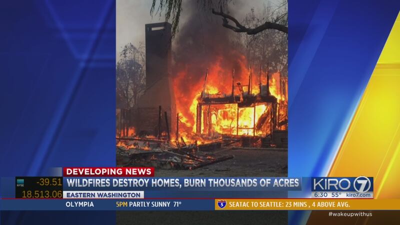
SPOKANE, Wash. — A series of wildfires burning in the Spokane, Washington, region have destroyed at least 16 homes. Firefighters continued to fight the blazes on Tuesday. See photos here. Gov. Jay Inslee declared a state of emergency for 20 Washington state counties Tuesday.
Key developments:
- Blazes in the Spokane region erupted Sunday afternoon.
- Authorities are referring to the fires as the Hart Road Fire, the Spokane Complex fire, and the Deep North Fire.
- State of emergency declared by Inslee for 20 Washington state counties.
- The state's biggest wildfire was near Kahlotus in Franklin County.
- At their peak, the blazes scorched more than 12,000 acres, which is about 18 square miles, Monday.
- Wildfires burning in eastern Washington have destroyed at least 16 homes.
- No injuries have been reported.
- All the fires erupted while the area is under a National Weather Service red flag warning.
- About 200 firefighters are battling that blaze in timber, brush and grass.
- See the latest evacuations here.
See an interactive fire map from the Northwest Coordination Center below or here.
Hart Road Fire
The Hart Road fire burned at 6,000 acres late Monday morning. By Tuesday, the fire near Davenport was 30 percent contained.
On Wednesday, the fire was burning an estimated 4,400 acres. Officials said 26 outbuildings had been destroyed.
At its peak, the Hart Road fire was estimated at 10,000 acres. The wildfire north of Davenport jumped the Spokane River on Monday and threatened dozens of homes, engulfing several of them.
Six homes were destroyed.
Hart Road fire is not part of the Spokane Fire complex, but you can read about it by scrolling down.
The American Red Cross has opened a shelter for people affected by the Hart Road Fire. The Lincoln County fairgrounds have been established as a temporary relief shelter for residents.
The evacuation zone included all residents within a three-mile area northeast of State Route 25 and Hart Road.
There have been no reported injuries.
The Spokane Complex fire complex
The Spokane Complex consists of two fires: the Wellesley Fire on the eastern edge of Spokane and the Yale Road Fire south of the city -- around the community of Valleyford.
%
%
The Yale Road Fire and the Wellesley Fire were first known as the Beacon Hill fire.
- The Yale Road fire was 5,708 acres as of Wednesday
- The Wellesley fire was 250 acres as of Tuesday
Multiple homes have been lost to the flames, fire authorities said.Spokane fire officials said the blaze was not under control Monday or Sunday.
One of the uncontrolled fire in the complex started Sunday afternoon near Spangle, Washington, which was south of Spokane.
The Washington State Patrol at least 10 homes and numerous other buildings were destroyed near Spangle on Sunday.
Residents evacuating from the Beacon Hill-area fire on Spokane's northeast end, where a blaze had scorched 250 acres by Sunday evening, met other homeowners trying to get into their properties, only to be met with roadblocks.
The Spokane newspaper said many were left wondering if their homes would be spared. Authorities say they are making progress on the fire north of Spokane.
DNR officials said Wednesday two homes had been damaged and twelve lost.
Law enforcement officials are in the area to notify those in the path of the fire.
Blaze near Kahlotus threatens homes, knocks out power
The state's biggest wildfire was near Kahlotus in Franklin County. It had burned more than 34 square miles on Monday and was still growing. Cause of that fire is under investigation.
A large fire that started on Highway 260 near Connell moved east toward Kahlotus, where it threatened homes and forced some residents to evacuate, according to The Tri-City Herald.
The fire, raging in the dry brush of the Columbia River Basin, was threatening homes and crops, but had not burned any homes, the State Patrol said.
Officials estimated the fire was burning over 22,000 acres.
The Deep North Fire
Another fire was burning north of the town of Northport, near the Canadian border. It was less than one square mile, but was threatening homes and power lines.
The
said the Deep North Fire broke out Sunday night .
A call came in Sunday evening from a person in the 2700 block of Deep Lake Boundary Rd. who said they could see smoke on a ridge.
DNR officials said Wednesday 735 acres had burned.
#WaWILDFIRE UPDATE - #DeepNorthFire: 800 acres in heavy timber near #Northport, Level 2 Evacs around #DeepLake. pic.twitter.com/7Pew34xdgV
— waDNR_fire (@waDNR_fire) August 23, 2016
Other top headlines from KIRO 7
Cox Media Group


