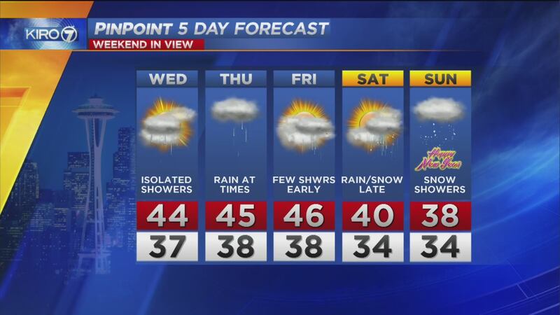
The coldest airmass seen in quite a few years will arrive along with the new year, and as we usually contend with when arctic blasts move in, there will be a chance for lowland snow.
We have had several of these episodes so far this fall and winter, but this magnitude of the cold air coming warrants preparation of home and vehicle regardless of whether snow accumulates.
>> Download the KIRO 7 weather app to get weather alerts around your home.
Rain to turn to snow over New Year's weekend
Forecast models are coming into quite a bit of good agreement heading into Friday that many of us will see snowflakes, and some spots will get some accumulation. However, a disruptive snow event is unlikely for most of us in the lowlands.
The best estimate is for the lowlands of Western Washington to mainly get rain showers during the daytime hours on New Year's Eve, though some locations north of Everett and higher hills could see some snow mix in late in the day Saturday.
The snow level looks to drop Saturday evening into early Sunday morning, leading to some snow reaching lowland elevations before dry air wins out and precipitation comes to an end during the morning daylight hours Sunday.
There will be timing changes which will impact the holiday celebrations, so stay tuned!
Lowland amounts of a trace to three inches look to be a probable range. Most lowland spots like Seattle would see a trace to an inch. As is usually the case, the higher in elevation one is, the better the chance of accumulating snow. Best amounts for more than two inches will be above 500 feet close to the Cascade foothills and in the north Interior.
As snow falls, ground temperatures will be relatively warm, so snow initially will melt on contact with road surfaces.
Sunday night and later, however, we'll have to watch for icy spots from moisture on roadways that freezes as the polar plunge continues and temperatures fall well below freezing.
Very cold air for an extended time next week
What we are more easily able to establish from a week or more out in time is the nature of the airmass over the Northwest. It looks... very cold. %
%
While the chill arrives for the new year, the coldest temperatures could well be in the mid-week time frame next week, after residual cloudiness clears out and winds diminish.
Early indications are that even locations along Puget Sound, including Tacoma, Seattle and Everett might not be able to get above freezing for several days. This would be a very unusual occurrence.
The last time we had three full days without reaching 32° in Seattle was just before Christmas 2008. Not unsurprisingly, we had significant wintry weather on the latter part of that extended cold weather outbreak. That is something we'll be watching again -- once the grip of the cold air is loosened. That could be as late as the weekend after next!
But, for the bulk of the time the cold air is in place during the Jan. 3-5 timeframe, we might expect overnight lows in urban locations to fall into the teens and 20s and outlying locations to be in the teens with even the colder spots in the single digits at night.
While timing and magnitude of the cold air will be adjusted as we get closer to next week, go ahead and think about what needs to be done to properly winterize your home and vehicles.
We'll be providing updates throughout the week and weekend on KIRO 7 News.
Follow me on Facebook and Twitter.
Stories trending on KIRO 7
- GoFundMe started to 'protect' Betty White from 2016
- Infant dies from starvation after parents die of apparent overdose, coroner says
- Download the KIRO 7 News app for breaking news alerts
- Delta cancels orders for 18 Boeing Dreamliners
- Everett officer hit by car amid crashes on icy roads
- WATCH: Cat attacks man excitedly opening Christmas present
Cox Media Group


