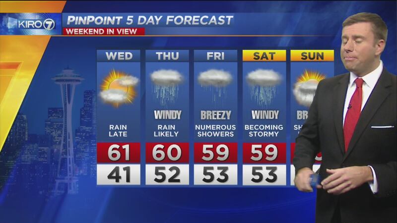
Get ready ahead of several bouts of heavy rain and strong wind starting Thursday!
With a potent and swift jet stream, plenty of available subtropical moisture and even energy from Typhoon Songda in the western Pacific, it's going to be an active period of weather starting Thursday and lasting through Saturday night.
>> Related: 8 things to know about storm systems heading to Northwest
The first storm to arrive will be on Thursday with a low pressure system that develops over the eastern Pacific and moves toward Vancouver Island. This won't be a very powerful storm but could bring wind gusts of 50 mph across coastal locations and the northern waters and islands, including the San Juans.
As of Monday evening, the data don't point to anything more than a breezy day Thursday for the remainder of Western Washington including all of Puget Sound. Still, with leaves on many trees, wind gusts of 30 miles per hour could cause sporadic power outages and leaves increase the wind force on branches and trees.
Friday looks blustery still but the focus will be on the strongest storm in our neighborhood on Saturday.
Remnants of Typhoon Songda will energize Saturday storm
Monday night, Typhoon Songda was southeast of Japan with winds of more than 100 miles per hour. As the storm moves north, it is going to be entrained in a swift jet stream -- or band of strong wind aloft -- rocketing eastward from Asia. %
%
This band of strong wind will rip the typhoon apart, so Songda will no longer have a name or tropical characteristics, but the remnants of the storm will bring additional moisture and wind energy to the mix as an extratropical low -- that's what our typical Northwest windstorms are -- develops in the eastern Pacific.
(It is not uncommon for typhoons to be involved in our significant wind storms in the Northwest. In fact, many of our historic windstorms have links to typhoons from the western Pacific.)
This storm will reach it's maturity by Friday and Friday night and will still be several hundred miles off our coast. The atmospheric pressure will be quite low -- a sign of a powerful storm -- and around 950-960 millibars, or 28.00 to 28.40 inches on your home barometer.
This will create a very strong wind field around the storm as it moves toward the British Columbia coast, arriving somewhere between northern Vancouver Island and the southeastern tip of Alaska by Saturday evening.
>> Related: A look at one of the most infamous storms in northwest history
As of Monday night, data point to a period of gusty wind for the Northwest but the center of the storm staying far enough away that we avoid widespread damaging wind. On this current and more benign track indicated by forecast models, we'd still likely have high wind of greater than 60 mph across the north Washington coast and possibly the northern waters and islands too. %
%
Wind elsewhere would probably gust in the 30-50 mph range. Sure, a good blow with some sporadic power outages, but not a terribly destructive storm in a widespread nature.
If the storm takes a more southerly track toward Vancouver Island and maintains this deep low pressure, then we'd be in danger for a much more damaging wind event on Saturday through Saturday night.
Those heading to the Seahawks game in Seattle Sunday will encounter blustery rain showers and temperatures in the 50s.
What to do now?
Even if this storm turns out to move inland well north of Vancouver Island, we can expect some wind-related power outages.
>> Related: As northwest braces for stormy weather, here's how to prepare
Go ahead and make sure you and your family have supplies like non-perishable food, water and batteries in case you lose electricity for an extended period of time.
Even if you don't need those supplies because of storms Thursday and Saturday, we are entering our windstorm "season" here through November. And with a "neutral" El Nino/La Nina pattern in place, the conduit for storms to affect us -- the Pacific jet stream -- will be close by. We simply have a greater chance of impactful wind events this fall than we have over the past few years.
I'll be updating the forecast regularly on my Facebook and Twitter feeds as new data come in, and of course on television on KIRO 7.
No cause for panic, but preparation!
Cox Media Group


