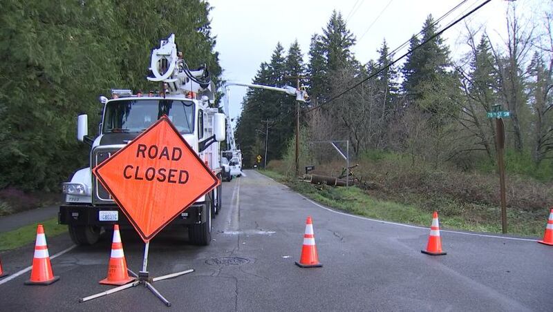
SEATTLE — Thousands were without power in some areas after high winds, heavy rain and hail swept across western Washington Monday.
It was a very busy afternoon, with a few non-severe thunderstorms mainly nearer the coast and north of Everett, with some small hail.
It was breezy to windy nearly everywhere in western Washington, and in the mountains, heavy snow continued to fall.
>>Download the KIRO 7 Weather App to get forecasts for where you live
Some people experienced thunderstorms and hail. Ashley Sturts from Everson said a lightning bolt struck her neighbor’s chicken coup, but the birds were not harmed.
The severe weather knocked out power for thousands from Bellingham to Olympia.
Puget Sound Energy reported more than 48,000 customers in western Washington, with many of those outages on Whidbey Island, in the North Sound and in Kitsap County. Seattle City Light reported nearly 1,500 customers without power as of about 8 p.m. Monday, which had improved from earlier reports of 7,000.
As of 6 a.m. Tuesday, the number of Puget Sound Energy outages was less than 5,000. See the outage map here.
In the North Sound, wind took down trees and power lines. In Mukilteo, crews were out in blustery conditions working to repair utility lines and clear away a fallen tree blocking the road at 44th Avenue West and 78th Street Southwest.
In Everett, the high wind was enough to bring down a tree near Interstate 5, causing a major hassle for some commuters. The usual ramp to southbound I-5 was sealed off.
It's pretty windy 🍃 out there...
— WSDOT Traffic (@wsdot_traffic) April 4, 2022
You can see a tree down on the side of the road along southbound I-5 near 112th Street SE / South Everett Park and Ride. Our crews are blocking the on-ramp to SB I-5 from 112th while we deal with the tree. @SoundTransit pic.twitter.com/PIoU2ejEGk
In Federal Way, a tree came down on First Avenue South, causing a closure between South 312th and South 320th streets.
In south Seattle, officials shut down 4th Avenue as power poles are leaning dangerously over the 4th Avenue South bridge.
WIND
A wind advisory was in effect through Monday afternoon in the Puget Sound region, with gusts ranging from 25 to 35 mph and some gusts up to 50 mph.
The strong winds slowly subsided Monday evening.
The wind advisories for Puget Sound and the high wind warning for north and west of Everett will likely expire at 8 p.m., and at the coast the high wind warning will expire at 11 p.m.
It’ll remain breezy to windy into Tuesday, but the strongest winds were Monday evening.
A Winter Storm Warning in effect for +2500' through 8am Tuesday. Snow totals of 5-15" of for Stevens & Snoqualmie Pass today; even more snow overnight into Tue.
— Claire Anderson (@ClaireKIRO7) April 4, 2022
Here is a look at the mountain pass conditions right now. @kiro7seattle #kiro7seattle #seattle #wawx pic.twitter.com/1KvncDE9V2
MOUNTAIN SNOW
The biggest story with the stronger storm was the heaviest mountain snow in weeks.
Snow increased in intensity on Sunday night and continued through Monday and into Tuesday before tapering off.
While the snow will be more sporadic, another five to ten inches of snow was expected by Tuesday morning with isolated higher amounts.
A winter storm warning is in effect until Tuesday for the entire Cascade mountain range.
Pass travel will continue to be difficult at times through the Tuesday timeframe, so travelers should keep that in mind.
Good morning. Seeing high winds in the low lands and heavy snow in the passes. Chains required on @SnoqualmiePass for all except AWD/4WD, chains required for vehicles over 10K gross vehicle weight on Stevens & White. Please be cautious wherever you're headed. pic.twitter.com/Q7hJgQIcBC
— Washington State DOT (@wsdot) April 4, 2022
LOOKING AHEAD
For Tuesday, expect occasional showers of rain and small hail and breezes in the 20-30 mph range with isolated higher gusts. Snow will also occur off and on in the mountains with a 1,500-to-2,000-foot snow level. Highs will be in the lower 50s in Seattle after morning lows in the upper 30s to low 40s.
Breezes and rain/snow showers will end Tuesday evening as a ridge of high pressure builds in.
With all the moisture at the ground, if skies clear Tuesday night we could start Wednesday with some pretty widespread fog that burns off by afternoon. Highs will be around 60 Wednesday in Seattle.
Thursday looks to be the warmest day of the year so far, with upper 60s for Seattle and some low 70s to the south. We’ll have plenty of sun Thursday.
Of course, if you like the warmer weather, it won’t last into the weekend, as skies will cloud up starting Friday and rain showers and mountain snow showers will return and persist into the weekend with some sunbreaks. We might also be dealing with afternoon thunderstorm chances over the weekend as well.
More news from KIRO 7
- Passengers stranded as more Alaska Airlines flights canceled again
- Planning to drive this East Pierce County highway? You might avoid it until late May
- Car dealership agrees to $10M settlement for allegedly charging Black clients more
- Do you have an investigative story tip? Send us an email at investigate@kiro7.com
The Associated Press contributed to this report.
©2022 Cox Media Group


