WASHINGTON — Happy Monday! An atmospheric river is over western Washington this morning, with pockets of rain and some gusty weather. Sunday was a really active day with some record setting rain, windy weather and some very minor river flooding. We do have a handful of river Flood Warnings, but most of the rivers will crest just barely above flood stage later this morning.
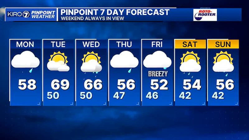
We’re mild in the low-50s this morning and will stay mild today and the next couple of days. The front is stalled over the area, but thanks to the rain shadow, we’re not seeing much rain in Seattle or Tacoma. The more consistent rain today will be around Everett north to the border and in the Olympics and North Cascades. For example, we could see around a half inch in Bellingham, but more like a tenth of an inch or less in Seattle, Tacoma and Olympia. Expect some light rain at times, but again, the more consistent and heavier rain will be to our north. Wind will stay around 10-15 mph out of the south, which is much calmer than yesterday! Highs will be in the upper-50s and lower-60s! Snow levels will be around 7,500-8,000′.
The rain will taper even more from south to north tonight, with just clouds and mainly dry weather overnight. Tomorrow then will be warm! We’ll have some clouds early and then increasing sunshine turning partly cloudy with warm daytime highs in the upper-60s and lower-70s! The record for tomorrow is 64° and my forecast high is 69°!
Clouds and showers will increase on Wednesday with mild weather and unstable conditions, thunderstorms with scattered showers will be possible.
We’ll go back to low to mid-50s by Thursday and Friday with more showers and even some breezy weather possible on Friday. This weekend will have scattered showers in the mid-50s....normal for this time of year in Spring.
©2025 Cox Media Group