WESTERN WASHINGTON — Much of Western Washington is expected to see up to an inch or two of wet snow on Wednesday before it later turns to rain. The exception is areas north of Everett and near the Cascades, which could get significantly more.
>>Download the KIRO 7 Weather App for live radar updates
On Wednesday night, we’ll likely see areas of rain turn to wet snow around Puget Sound from south to north after 5 p.m. Some of the snow will come down at an alarming rate, causing accumulations of slush in the lowlands.
Higher elevations — spots above 400 feet and close to the mountains — will have a better chance for snow to accumulate. However, it looks like progressively warmer air will move southward into the region tonight, possibly after 7 to 8 p.m., to Olympia and Tacoma. Any snow that falls should begin to turn back to rain.
From Seattle to Everett, we could see wet snow from 9 to 10 p.m. before it changes back to rain.
Although these are just rough estimates — heavier precipitation could be more snow and lighter precipitation could be rain, which creates a back-and-forth scenario that is very difficult to forecast.
>>KIRO 7 PinPoint 7 Day Forecast
CENTRAL/SOUTH SOUND:
Any lowland snow that accumulates from Snohomish County south should be minor at best (less than two inches) and then melt or be washed away by the warmer rain into Wednesday night and Thursday. There will likely be no travel impacts from about Everett south but any “burst” of snowfall could cause brief issues. Drivers should be watchful, not only for problems with brief bursts of snow but as the rain moves in and gets heavier, it could cause standing water and urban flooding.
NORTH OF EVERETT:
Looking north of Everett and in the higher elevations of Snohomish County and north through Skagit, Whatcom, Island, San Juan counties, and along the strait around Port Angeles, we’ll hold onto snow later into the night. In fact, around Bellingham, the continued dry and cold wind coming out of British Columbia could hold off snow there until nearer midnight, followed by several hours of heavy snow. In the areas mentioned, we should expect 1 to 3 inches of wet snow followed by rain into Thursday, though accumulations will be highly variable and it is possible many spots will turn to rain, resulting in no snowfall accumulation. However, in Whatcom and Skagit counties, expect 3 inches or more of snow late tonight into Thursday morning and a Winter Storm Warning is in effect.
AREAS WITH SNOW:
In North Bend and near the Hood Canal region, as heavy rain begins later Wednesday evening, the added load of rain on snow could cause tree damage or even roof collapses. In addition, urban flooding is likely in spots where the heavy rain cannot run off due to piled up snow and ice, which will melt slowly.
>>Upload your weather photos, video
MOUNTAINS:
In the Cascades for Wednesday night into Thursday, a Winter Storm Warning is in effect. The snow will become very heavy after about mid-evening and the closure of passes is almost a guarantee at times Wednesday night into Thursday. Snoqualmie Pass stands to pick up 1 to 2 feet of snow while Stevens Pass and Mount Baker could pick up 2 to 3 feet or even more. Snowfall rates will be very high and blowing and drifting are likely. Across the south Cascades, snow levels will rise tonight to above 5,000 feet, so we could turn to rain at White Pass and Paradise. All told, travel through the mountains is not advisable from later this evening through Thursday, and avalanche danger will be high.
Scroll down to continue reading
1 of 31


LOOKING AHEAD
RAINY LOWLANDS FOR THURSDAY:
As the warm front sets up across the region, expect heavy rain at times on Thursday — especially along the coast, the central and south Sound, the Olympics, and the south Cascades and into southern Washington. Locations from Seattle south could see 1 to 3 inches of rainfall from Wednesday night through Thursday night. This will cause urban flooding problems in spots and also cause rivers flowing out of the south Cascades to rise. Travelers should use caution as standing water will be an issue.
FRIDAY RIVER FLOODING:
The rivers off the south Cascades and south Olympics will flood on Friday with the Chehalis River around Grand Mound forecast to reach major flood status on Friday afternoon and evening. The other rivers to reach moderate flood status are the Skokomish, Skookumchuck, and possibly the Snoqualmie River at Carnation.
WEEKEND AND BEYOND:
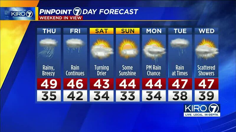
We’ll be drying out over the weekend after some rain on Friday. Next week looks pretty quiet with snow levels above the lowlands to give relief to those dealing with wintry weather. We could have some rain showers around Tuesday but nothing significant. Highs will be in the 40s and lows in the 30s.
More news from KIRO 7
- 3 shot dead in Auburn, including child
- Body found in trunk at Graham auto yard identified as missing woman
- Body of woman found inside Federal Way home
- Do you have an investigative story tip? Send us an email at investigate@kiro7.com
©2022 Cox Media Group