WESTERN WASHINGTON — Cooler air is starting to work its way in across Western Washington, but Wednesday will still be a hot day.
Onshore wind will be light to start the day, but increase as the afternoon goes on, helping to push even more cool air inland tonight.
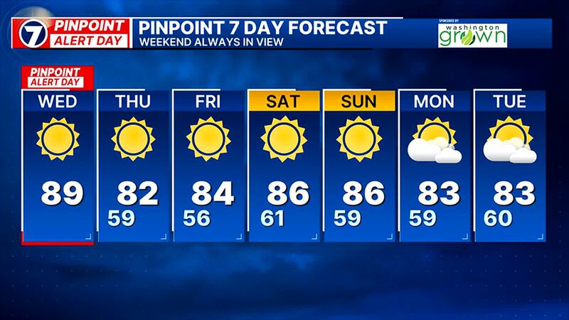
We have some low clouds at the coast, the Strait and even parts of southwest Washington. It will be very sunny inland, but our highs will drop around 7 to 10°. The standing record for Wednesday is 90° in Seattle and I have us getting to 89°.
We still have the Heat Advisory for portions of Western Washington until 5 p.m., which means it’s a PinPoint Alert Day to match the advisory.
It will be much cooler at the coast in the 60s and 70s, and around Everett and north it will be in the upper 70s and lower 80s. Inland, the hottest areas will be closer to the Cascade Foothills, with highs in the low 90s.
A Red Flag Warning is in effect for areas east of the Cascades. Conditions now are hot and dry but on the east slopes and into Central Washington, winds will become gusty out of the northwest through the day Wednesday with some gusts around Ellensburg and Yakima regions topping 40 mph late in the day. Any active or new fires could spread quickly.
Happy Wednesday! It's another warm morning & it is another PinPoint Alert Day, however, it will be cooler. We could still be near record highs, but we'll drop around 7-10°. We'll walk you through the cool down & look ahead to the weekend. #NickKnows #wawx pic.twitter.com/sMsBtUTzsP
— Nick Allard (@NickAllardKIRO7) July 10, 2024
Cooler air arrives for all Wednesday night and Thursday with highs back in the 70s to low 80s – still warmer than average but nothing like what we’ve been through. We’ll have clouds each morning that will clear quickly for sunny afternoons.
It remains mainly sunny with Seattle highs in the mid-80s and morning lows in the upper 50s well into next week. There are no substantial rain chances out there through the middle of next week, and likely beyond.
©2024 Cox Media Group