SEATTLE — Strong wind gusts and thunderstorms around Puget Sound earlier Monday evening have moved out, and as a potent area of low pressure makes landfall around Vancouver Island in the coming hours, pressure gradient with wind flowing into the storm will ramp up winds around all of Western Washington over the coming hours, lasting into Tuesday morning.
- The High Wind Warning areas are for the King and Kitsap County areas nearer the water, including Seattle and Tacoma, and south through southern Washington and the coast. Winds from the 10 pm-5 am time frame will reach over 50mph in these areas with wind gusts over 60mph at the Pacific beaches and isolated locations around the interior (especially on/near water).
- The Wind Advisory areas are for other locations in the north Sound, north interior, and locations nearer the Cascades for wind gusts in the 40-55 mph range, though higher gusts are possible in these areas too.
- The warnings and advisories are in effect until 10 a.m. Tuesday.
This storm system is more of a “typical” Pacific windstorm, and not a “bomb cyclone” as it is significantly weaker than the historic November storm. It will also be producing primarily southerly and southwesterly winds, which is more common with wind events in Western Washington, but it also means that the heavily-populated locations on the eastern side of Puget Sound will receive more wind impact, including coastal King and Pierce counties.
While the storm system will be weakening as it makes landfall, this will still be a longer-duration wind event than many we see with strong winds lasting upwards of six hours or longer before finally subsiding through the first half of the day Tuesday. This prolonged period of windy weather will threaten greater power outages across the area. The impact from this event will stretch through the Tuesday morning commute.
In addition to the wind, heavy rain will occur at times tonight through Tuesday morning. There is also a threat of isolated thunderstorms, mainly Monday evening and Monday night.
In the Cascades, a Winter Storm Warning is in effect tonight through Tuesday afternoon for 12-18 inches of snow. Heavy snow banding at times could produce whiteout conditions and pass closures.
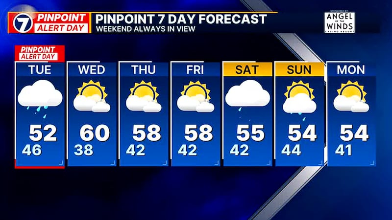
Through Tuesday afternoon in the lowlands, winds will be continuing to subside across the area and rain showers will be tapering. We will also have periods of sunshine.
From Wednesday through the end of the work week, weather will be quiet with some clouds and sun and highs in the 50s to near 60. A chance of rain showers returns this weekend.
By 4 a.m. Tuesday, counties across Western Washington were experiencing power outages, downed trees, and bridge closures.
Down tree on Boren Ave at Seneca St blocking the right NB lane. Use caution. pic.twitter.com/mwj5L34c4w
— SDOT Traffic (@SDOTtraffic) February 25, 2025
SR 104 Hood Canal Bridge is closed to traffic until further notice due to high winds. Crews are standing by to reopen when conditions allow. This 2016 video shows why we need to open the draw span in high wind to protect the bridge. https://t.co/m2FZxNUM3K pic.twitter.com/MrwHJX3PJt
— WSDOT Tacoma (@wsdot_tacoma) February 25, 2025
Another burst of storm activity has caused multiple outages impacting approx. 23,000 customers. Crews are responding and will continue to work as quickly and efficiently as safety allows. Follow our outage map for the latest updates https://t.co/ntpXQJIc2C. pic.twitter.com/B1hIciBXzg
— Seattle City Light (@SEACityLight) February 25, 2025
Along State Route 9 in Woodinville, crews worked to clear a downed tree from the road early Tuesday morning.
1 of 8


PUD crews worked to restore power to several scattered outages including:
- Humptulips & Quinault: Amanda Park, Queets, Kalaloch, Clearwater Rd
- South Beach: Newskah Rd, and along St Rt 105 to Westport, Westhaven, Grayland, and Tokeland
- North Beach: Copalis Beach, Copalis Crossing, Park 400, Moclips, Pacific Beach, Seabrook, Taholah, and parts of Dekay Rd
- Central Park & East County: All of Central Park, East Hoquiam Rd to Wishkah cut over, Middle & West Satsop Rd
©2025 Cox Media Group