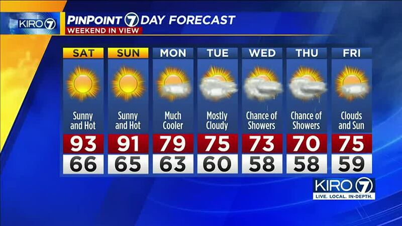
SEATTLE — Just when we thought the heat wave was coming to an end, an excessive heat warning for the Puget Sound region that was set to end on Saturday night has been extended.
>>Find cooling centers near you
>>How to stay cool if you don’t have AC or can’t open windows
Early Friday, the National Weather Service extended the warning to Sunday at 9 p.m.
With the potential for another 90-degree day on Sunday, we could set a record for the most consecutive days of at least 90 degrees in a row.
As KIRO 7 Chief Meteorologist Morgan Palmer mentioned Thursday night, “that has not occurred in Seattle weather history going back to 1945 at Sea-Tac Airport, and there are no records of such a stretch in earlier years at the old Federal Building in Seattle, and those records go back to 1896. So, this is very significant and something we’ll be watching closely.”
At the coast on Friday, expect what we in the weather community call “pea soup” skies. Essentially a high-pressure system sinking warm air pushes down on coastal fog creating a warm (with 70s right along the coast) but gloomy day.
With the absence of the marine layer out toward central and eastern Washington, it will just be hot, with more triple-digit temperatures and clearer skies.
If there’s any good news, it’s that next week it will be cooler across the state. You can thank incoming “onshore flow” (air heading from sea to land making conditions cooler). I’ve touched on this a couple times this week as the presence of onshore flow has kept some of our coastal areas refreshingly cool and the absence of offshore flow (air heading from land to sea) has kept us from getting warmer than we have around the interior.
Another event I’m closely monitoring is the possibility of mountain thunderstorms heading into next week. After this significant dry period and tall grass and shrubs drying up immensely, our risk of wildfires will be exceptionally higher.
©2022 Cox Media Group


