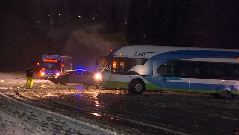
After a record high in Seattle of 59 degrees and record daily rainfall with flooding, snow fell in many spots in the central and north Sound Monday evening.
Tuesday morning, we are off to a much calmer start. Most areas are above freezing, but we have some isolated areas west and north of Puget Sound where temps are below freezing.
Snow that arrived Monday has already melted in most areas. We also have a little lingering moisture and some patchy fog with snow in the foothills and mountains. The moisture will wrap up today and any lingering showers will be in the Cascades. Meteorologist Nick Allard said he even expects some sunshine Tuesday afternoon with highs in the mid-40s.
Wednesday will be chilly to start in the 20s and 30s, but there should be plenty of sunshine for the afternoon. Look for more sunshine on Thursday with increasing rain on Christmas Day.
We should see some more rain on Saturday and then drier conditions on Sunday and Monday.
Monday snow coverage:
Snow first hit Whatcom County on the first day of winter, and other parts of western Washington saw some snow that started late Monday morning into the evening.
Just after noon, just north of Bellingham on I-5, snow could be seen from WSDOT cams.
Looking like a Winter Wonderland right now on I-5 just north of Bellingham! @KIRO7Seattle #kiro7seattle #bellingham #wawx pic.twitter.com/mvwejyhEM1
— Claire Anderson (@ClaireKIRO7) December 21, 2020
In Blaine, snow falling was captured on video.
Dumping #snow near #Blaine, WA! #wawx @NWSSeattle @MorganKIRO7 @ScottSKOMO @BenjaminJurkovi @bhamMitty @wheeler244 @KSeattleWeather @WestSeaWx @weatherchaser5 @ensembleator @50ShadesofVan @Brad604 pic.twitter.com/tQ151ZE3kT
— Randy Small - Whatcom County Weather (@RandySmall) December 21, 2020
Snow up at the Port of Friday Harbor! @KIRO7Seattle #kiro7seattle #seattle #fridayharbor #wawx pic.twitter.com/r0OIQA4Rce
— Claire Anderson (@ClaireKIRO7) December 21, 2020
>>PHOTOS: Snow falls across parts of Puget Sound
Also, parts of western Washington saw heavy rain come down as lots of storm drains got clogged and drainage systems could not keep up with the rain.
Apocalypse Now? 😱 🌧
— Lauren Donovan (@LaurenKIRO7) December 22, 2020
Check out how bad the flooding is in Pioneer Square! Seriously it’s like you’re out boating. @KIRO7Seattle pic.twitter.com/T6Frzfxoi8
The Lynnwood area was hit by widespread flooding and snow, but slush on the roads melted almost as quickly as it came.
Snow didn’t last long and a lot of roads have already cleared up but some will remain closed overnight because of flooding— LIVE 11p w/ video of today’s wild weather 📲 https://t.co/mOge9e0xf9 @KIRO7Seattle pic.twitter.com/MJAnovqUn1
— Michael Spears (@MichaelKIRO7) December 22, 2020
Airport Way in Everett was slick and dangerous. Buses and cars got stuck and slid around. KIRO 7 saw a bus struggling near 128th Street Southwest.
>>DOWNLOAD KIRO 7′s WEATHER APP HERE
From Whatcom County down, drivers risked trudging flooded roads in areas as the rain’s fury was felt even on a flooded 216th Street near 68th Street in Mountlake Terrace. A man was seen walking in water that was knee-deep in places.
Some drivers ran into trouble. KIRO 7 saw a Lexus and a Mercedes get stuck.
Just watch this car drive thru a flooded road and not make it. Driver still inside. @KIRO7Seattle @MorganKIRO7 @ClaireKIRO7 pic.twitter.com/pb4UNkEI7Y
— Mike Griffith (@PhotogGriff) December 22, 2020
“A lot of cars start going by, and they think they’re going to make it, but they get stuck,” said Ramiro Tinoco, who worked near the flooded area.
Tinoco said he and his team had a busy night ahead de-icing parking lots and sidewalks.
While many roads cleared, some others remained flooded.
The city of Bellevue said several roads would remain closed overnight, including the Lake Hills Connector at Southeast 7th Place.
The heaviest totals of 1 to 3 inches fell from Whatcom County through Skagit, Snohomish and north King counties away from the water and above 300 feet elevation. SEA in Sea-Tac had a half-inch of snow.
At around 11 p.m., the Washington State Department of Transportation tweeted that due to multiple collisions, I-90 was closed in both directions from North Bend at milepost 34 to Easton at milepost 70. It was reportedly snowing hard in the area. The interstate has since reopened.
UPDATE: The closure is now between North Bend MP 34 to Ellensburg MP 106. Crews are on scene removing several collisions.
— Snoqualmie Pass (@SnoqualmiePass) December 22, 2020
Cox Media Group


