SEATTLE — It remains windy Wednesday afternoon with showers and sunbreaks.
>>Download the KIRO 7 Weather App to track the storm live on your phone
For tonight, though, expect mainly dry conditions with temperatures falling into the upper 40s by morning.
WIND
We have wind advisories from just north of Olympia to the Canadian border. We are near the end of the peak of the strongest wind, but even as it calms down a bit, it will still be windy. We hit 55 mph at Bellingham and 44 mph in Everett.
For the Puget Sound region and points south, it will be windy through the afternoon. The most common speed for wind gusts will be in the 25 to 35 mph range, though isolated gusts of more than 40 mph are possible, especially near water and on exposed hilltops. As is always the case, there will be a large variation in wind gust speeds across the area because of the varied topography.
>>VIDEO: Doppler radar, latest forecast on KIRO Weather 24/7
During the fall, this would be a run-of-the-mill wind event, but in the spring, with trees having all their leaves and it having been several months since we last had strong winds, I expect some sporadic tree damage and power outages on Wednesday.
East of the Cascades, winds will gust over 50 mph with blowing dust likely.
The wind advisories denoted in the map below remain in effect until 5 p.m. or 8 p.m. See a full list of severe weather alerts here.
Shortly after noon, Seattle City Light reported reported a power outage affecting nearly 5,000 customers in the North Seattle neighborhoods of Broadview and Bitter Lake.
Believe it or not, a Wind Advisory is in effect for a good part of the day with gusts in the 40mph range possible! #NickKnows #wawx pic.twitter.com/GVHNPqWBIO
— Nick Allard (@NickAllardKIRO7) May 18, 2022
Just after 1 p.m., a tree was reported down onto a powerline in Kirkland near Simmonds Road and 100th Avenue Northeast. The city of Kirkland said to expect delays and to use caution around the area.
A tree has fallen on a power line near Simmonds Rd and 100th Ave NE. Crews have blocked the eastbound lane of Simmonds Rd. Expect delays. Please use caution. pic.twitter.com/lNVZp1TtHj
— Kirkland, Washington (@kirklandgov) May 18, 2022
A second tree fell across Lake Washington Boulevard between East Interlaken Boulevard and East Foster Island Road at the Washington Park Arboretum. Seattle Parks said it would take 2 to 3 hours to clear the tree.
A large fallen tree is blocking Lake WA Blvd. between E Interlaken Blvd. and E Foster Island Road at the Washington Park Arboretum. Crews will be working in the area for the next 2-3 hours to clear the tree. Check back here for updates. pic.twitter.com/d42d779s9z
— Seattle Parks (@SeattleParks) May 18, 2022
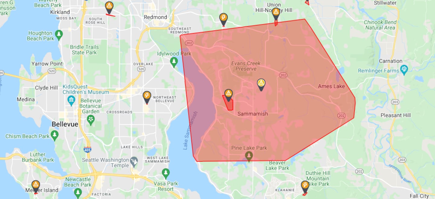
At around 1:30 p.m., a power outage affecting nearly 13,000 customers was reported in the Sammamish area by Puget Sound Energy. The cause of the outage is unknown at this time.
RAIN
The rain Wednesday will be concentrated in the first half of the day around the lowlands, with showers tapering in the afternoon along with some periods of sunshine. Most locations around the Puget Sound will get a quarter-inch of rain on average.
MOUNTAIN SNOW
It will be cold enough after the frontal passage from Wednesday afternoon through Thursday morning for snow to fall down to around 4,000 feet. Mount Baker could get more than a foot of snow, and Paradise nearly as much. Stevens Pass could get 4 to 8 inches of snow so U.S. 2 might bear watching on Wednesday night and Thursday morning, in particular.
There is a chance for a period of snow or rain/snow mix at Snoqualmie Pass on Wednesday night, but this is uncertain and it will probably be too warm for anything but brief and minor accumulations, but this will bear watching, too.
BEYOND WEDNESDAY AND EARLY THURSDAY
Showers will taper through the day Thursday and there will be some sunshine by afternoon. On Friday and Saturday, warmer temperatures will greet us for the weekend with more sunshine — an excellent forecast to get outside! The forecast high of 68 for Seattle on Saturday would be the warmest temperature since the area got into the 70s back on April 7, and just one degree warmer than average for the date.
Sunday could be almost as warm, though a few more clouds might move in and perhaps some late-day showers.
Some rain will move back in by Monday.
More news from KIRO 7
- The outer loop of Point Defiance’s Five Mile Drive is permanently closing to cars: Here’s why
- Officer shoots dog after child is attacked in Auburn
- The real estate contract that will follow you to your grave
- Do you have an investigative story tip? Send us an email at investigate@kiro7.com
©2022 Cox Media Group


